Wednesday, March 21, 2012

Cape Spear and Signal Hill, St. John's, Newfoundland, 11 & 12 July 2011

After our morning of whale and bird watching outside Bay Bulls, we drove back north to
Cape Spear, the easternmost land in North America. Cape Spear is the finger of land at the far right center on this map.


On the way to Cape Spear, we stopped briefly in Petty Harbour on Maddox Cove for some picture taking; this tiny harbor is accessible by the narrow opening in the breakwater that shields the moorage. Unlike many of the harbors on the Avalon Peninsula, this one faces northeast, open to the worst of winter's winds.


We were again lucky with weather - when we arrived at Cape Spear the wind was blowing, but it was warm enough to shed our jackets.


The Cape Spear lighthouse was first built in 1836, as a stone tower with a frame house for the light keeper's family built around it. It is the oldest surviving lighthouse in Newfoundland. The same family, the Cantwells, have been keepers of the light since 1846, with each generation assuming the duties in turn. I imagine that today's supervisor of the fully automated light has a much easier job than his great grandfathers did - they had to clean the lamp every day, climb the stairs toting heavy cans of oil, and keep watch through the night to ensure the light kept burning. The current lighthouse, built of concrete in 1955, houses the modern light that was installed in the old lighthouse in 1912.


As we walked around the cape, we marveled at the tenacity of some of the plants - this blue flag iris is managing to survive in a most precarious position.


The coastline here, as with most of the Avalon Peninsula, is very rugged, with constant wash of waves and wind shaping the great mound of rock that makes up the land. The colors of the water ranged from deep blue to icy turquoise on this nice sunny day.


During World War II the country of Newfoundland cooperated with both the Americans and the British to man gun batteries designed to keep the port of St. John's safe from enemy incursions. The guns have rusted and the lifting mechanism is long gone, but the bunkers survive, and are cold and dank.


Looking northwest from Cape Spear, the entrance to St. John's Harbour is visible as a low spot to the left of Cabot's Tower atop Signal Hill - just barely visible in the center left of this picture of St. John's Bay.


The next day, we toured Signal Hill (so named by the British in the late 1700's, but popularly still called by its original name of "The Lookout"). From the early 1700's through 1962, spotters would watch from the top of the hill and signal down to the businesses along the wharves when an incoming ship was seen. Each company had its own flag that would be run up the pole by the spotter and seen by watchers down below in the harbor so they could prepare for the arrival of one of their ships.
Cabot Tower was built in 1897-1900 to celebrate Queen Victoria's Golden Jubilee and the 400th anniversary of John Cabot's landing in Newfoundland. St. John's Harbour is completely landlocked except for a narrow entrance protected by Signal Hill on the north and a smaller hill on the south. At the Battle of Signal Hill in 1762, the French ceded St. John's to the British. In 1901, Gugliemo Marconi received the first transatlantic wireless radio transmission here, sent from Cornwall, UK.


The narrows are 600 feet across, with just a 200-foot-wide, 35-foot-deep shipping channel. The entrance is marked by a light on Cahill point, which was protected by gun batteries during WWII. The old concrete bunkers are all that is left of these gun placements, but the lighthouse remains active to the present.


The harbour itself is quite small, 1.2 miles long and only half a mile wide at its widest. Approximately 1200 commercial ships visit this harbor every year. Looking down from Signal Hill, one can see the entire harbor, all of downtown St. John's, and beyond. Since the mid-1700's, gun batteries have been placed around the hill to protect the harbor. Several of these are recreated by Parks Canada as part of the Signal Hill National Historic site.
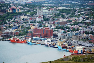


This is the view of the eastern end of the harbor and downtown St. John's, which marches up the hillside with a convoluted series of narrow roads - clearly a city that was built before the advent of the automobile. The church in the upper center of the photo is the cathedral of St. John the Baptist, which will be featured in the next post to this blog.

Wednesday, February 29, 2012

Whales and Birds in Bay Bulls and Witless Bay, NL 11 Jul 2011

Although the day started out cool and misty, we again enjoyed great weather for our boat trip out of Bay Bulls, south of St. John's. Bay Bulls was the first permanent English settlement in Newfoundland, being occupied at least seasonally since 1635. Over the next 2 centuries, French forces repeatedly invaded and burned the town during the struggle between France and England for control of Newfoundland. Each time, the English and Irish inhabitants rebuilt the town and continued their successful fishery. The deep bay is sheltered by headlands on both sides, and opens to the southeast, providing a harbor sheltered from the worst winter storms.

After an initial engine problem and transfer to a different boat, we were off. We motored along the shore, and wondered how the boat in this photo ended up way up above the water line.


All through Newfoundland, people paint their houses in bright cheery colors - perhaps to offset their long, dark winters?


A pretty waterfall cascaded down the rocky face of the headland. This picture really illustrates why they call Newfoundland "The Rock" - the whole island is rock covered by very thin soil.


The first whales we saw were fin whales - the longest of the whale family, with just a small fin set way back on their bodies. This whale has its head to the right, and the fin on the left - its back end and flukes aren't visible. Be sure to click on the photo to see a larger version. These whales move very quickly, up to 12.5 miles per hour, and we were lucky to have them in sight long enough to get several good pictures.


As the fin whales swam off, we spotted a group of humpback whales, who came right up alongside our boat. A mother and her calf were so close we could almost touch them.


When a whale exhales, you don't want to be down wind - their breath is quite odoriferous. Whale poop on the otherhand, is actually quite pretty!


After watching the whales for a good long time, we continued south along the coast to the Witless Bay Ecological Reserve, a group of 4 islands that serve as a nesting colony for puffins, murres, and razorbills. Only research scientists are allowed to land on these islands - the rest of us look from the sea. Since these rocky islets rise quite steeply, we were able to get close enough for a good look. If you click on the photo, you can see many birds flying overhead (all those black spots in the sky).


Puffins dig burrows in the hillside as their nests, and what looks like just a grassy hillside is actually pocketed with hundreds of puffin homes.


Tom was able to get a much better picture of the razorbills here than at the Cape St. Mary's rookery. The razorbills have interesting white cross-hatching on their heavy bills.


More puffins:

The green tent is a shelter/blind for the scientists who observe the colony. I can't say I'd like to spend much time perched right above all these birds with their smelly output!

After we returned to Bay Bulls, several of our caravan members met at a local restaurant for what was becoming our standard Newfoundland lunch - fish and chips made with incredibly fresh haddock, and seafood chowder that was different at every place, but always delicious.

In the afternoon, we went to Cape Spear on our way back to our temporary home at Pippy Park in St. John's - Cape Spear and Signal Hill will be the next subject covered in this blog.

Friday, February 24, 2012

Cape St. Mary's Ecological Reserve, July 9, 2011

We arrived in Argentia, NL, early in the morning and were situated at the nearby RV park by 10 am. Since it was a beautiful day we decided to drive to Cape St. Mary's Ecological Reserve, about 50 miles down the coast. This reserve has the most accessible seabird colony in North America, and hosts thousands of nesting Northern Gannets, Muerres, Razorbills, and various sea gulls. The interpretive center is staffed by knowledgeable rangers, and houses interesting displays of the natural inhabitants of this peninsula.

We did the easy walk out to the cliffs where the birds were roosting, and were lucky to find a ranger out at the point helping people identify the various birds.

When following the path across the barrens that cover the Cape, it was hard to imagine what lay just beyond:
This low, sparse vegetation is typical of the area - high winds, harsh winters, salt spray, and shallow soil all combine to keep the plants in check.


Soon we began to see the rugged cliffs, some 425 feet high. The center section in the photo at the left is actually a sea stack, completely separated from the land behind. The separation provides excellent protection for the nesting birds from land-based predators.
The rocks appear white from the thousands of birds roosting on the tiniest of ledges. By the time we were this close, we could hear the cacophony of screeching birds.


In the crevasse in the cliff, common muerres and the occasional razorbill crowd close in their precarious nests.


These are Northern Gannets with their fluffy chicks. The two in the center were engaged in quite a bill-rubbing, head-bobbing, wing-spreading dance. Be sure to click on the photos to be able to see the details!


While we were busy watching the birds, the ranger spotted this minke whale just off shore. All the little black specks on the water are actually birds floating on the surface, and the big white dots on the left are flying gannets.

As we were walking back across the barrens, Tom spotted this male willow ptarmigan in his colorful summer plumage. We figured that a female and her nestlings were probably close by, but we could not see them.
 As with so many of our days in Newfoundland, we were fortunate with the weather - on the day we went Cape St. Mary's, it was sunny and fairly warm. The next day, when we drove the 83 miles across the Avalon Peninsula from Argentia to St. John's was quite stormy, with intermittant rain and high winds. Barbara was very glad for our Comfort Drive steering, which makes handling the motorhome relatively easy even in adverse conditions. The roads were good, and we arrived at Pippy Park, a very nice municipal park with a big RV section, without incident.
Over the next week, we will post three more posts about our adventures in the St. John's area.

Sunday, February 19, 2012

Nova Scotia to Argentia, Newfoundland; 8-9 July 2011

After our six nights in Nova Scotia, we all prepared for the overnight ferry ride from North Sydney, Nova Scotia, to Argentia on the Avalon Peninsula in southeast NL. All 20 rigs caravaned the short distance from Arm of Gold Campground to the ferry dock at the end of the highway. We showed our tickets, attached the provided tag to our propane tank, and lined up for the wait:
We had to be at the ferry dock two hours before sailing time, so we had plenty of time for more visiting and sharing snacks. Shelby had her last chance to relieve herself before being shut in the motorhome for the 14-hour ride. We could have put her in the kennel on board, which would have allowed us to visit her, but after seeing and smelling the kennel we decided we'd made the right choice in leaving her at home.


Our ferry, the Atlantic Vision, is one of the larger of the ferries owned by Marine Atlantic. It runs only in the summer time across the Gulf of St. Lawrence and the Cabot Strait to Argentia; in the wintertime, only the much shorter run to Port au Basques operates. In this photo, the ferry is partially obscured by the Marine Atlantic offices.

Once our motohomes were all lined up inside the lower deck of the ferry, we climbed five flights of stairs to pick up the key to our stateroom, then after we'd stowed our overnight stuff, we wandered around the decks watching the loading process. One of the smaller ferries, the Leif Erikson, was arriving from Port au Basques on the southwestern tip of Newfoundland. We were surprised when the bow of the boat opened up even before the ship docked:


As the boat came into the dock, a ramp extended out the open maw to the exit lane. The power of the four bow and stern thrusters that positioned the boat at the dock was quite impressive.

We finally got underway at about 5:30 pm, and slowly made our way out of Sydney Harbor, eyeing the shoreline as we went:

After a social hour with our traveling mates and dinner in one of the dining rooms on board, we retired for the night. The seas were amazingly calm, leaving only the slight vibration of the ship's engines to let us know we were on the water. We would have slept soundly if not for the fact that the built in twin beds were hard as rocks, making it difficult to get comfortable. In the morning we had a buffet breakfast, then again hit the decks to watch our travel up Placentia Bay and into Argentia harbor:
 In the slight mist of the morning, these islands that fill the bay looked serene but mysterious.


A group of us gathered on the foredeck to watch the docking process:

From the left: Anna Leuenberger, Barbara, Sigi Dinse, Ken Jenkins (our wagonmaster), Jim Ploesser, Ursula Dinse, and Ray Leuenberger. Note the ever so stylish caravan jackets - we felt like bumblebees (and I opted for the warmer jacket that I won as a door prize in Shediac, NB)!


After a very short trip from the ferry to the aptly named Sunset Park, Tom walked up the adjacent hill and took this photo of our ferry at the dock. There's not much infrastructure left at this World War II installation:

The weather was lovely, sunny and not cold, so after we were settled, we unhitched the car and drove down to the Cape St. Mary's Ecological Reserve, which will be the next topic posted to this blog.

Friday, January 27, 2012

Newfoundland Caravan - First 4 Days

Hello from Tom and Barbara - we are finally ready to send a number of posts about our travel to Newfoundland in July 2011 with 19 other Newmar motorhomes. The caravan spent our first few days in Halifax and Bras d'Or, Nova Scotia before taking the ferry to Newfoundland. This post covers our time in Nova Scotia. Note: if you click on any of the photos, you can see a larger version for more detail.

Our first adventure from Halifax was to drive south on the coast to the picturesque towns of Mahone Bay and Lunenburg.

The coastline is very rocky and convoluted, with many scenic vistas and secluded coves.


Mahone Bay is a town of many churches, narrow streets, and lovely homes. We were glad we weren't driving the motorhome, as the main street around the bay is very narrow!

We did not stop in Mahone Bay, but enjoyed the drive through the town on our way to Blue Rocks.


 Blue Rocks is a small fishing community built on the very rocky shore east of Lunenburg - we weren't at all sure we were on the right road, as signs were rare - but at the end of the road, a local resident assured us that we'd reached the right place.

Each little cove had a mix of working and pleasure boats at anchor. In the gap between islets in the photo above, you can see a group of sea kayakers, who were enjoying the sheltered waters and lovely day.


We wondered how this sailboat managed the narrow entrance into this small bay - the water is full of barely submerged rocks waiting for the unwary mariner.


Back in Lunenburg, we were entranced by the brightly colored buildings. The entire town is a UNESCO World Heritage site.

We had a delicious lunch at The Old Fish Factory restaurant, overlooking the bay. It seems that each restaurant in Nova Scotia (and in Newfoundland) has a version of fish chowder - the Old Fish Factory served one of the best we had.

At the right is the view from the restaurant out over the bay.
After lunch, we toured the Fisheries Museum of the Atlantic, housed in an old fish processing factory and ice house along with the restaurant. The story of the rise and fall of the commercial fishing industry in Nova  
Scotia and the rest of Atlantic Canada is told through a series of interesting exhibits, and several ships are available to tour at dockside. Lunenburg was once a major ship-building port, and home of the famous Bluenose.


The next day we toured the Halifax waterfront, then walked up the hill through downtown to join the rest of our group for a back stage tour of the Royal Nova Scotia International Tattoo - an amazing annual variety show of short performances by groups from around the world - everything from bagpipes to dance to acrobats to military demonstrations, all in a fast-paced succession. We really appreciated all the organization that goes into such a production as we watched the performance that evening.

After our time in Halifax, we drove the 245 miles to the northern town of Little Bras d'Or, where we stayed at the Arm of Gold campground before embarking on our long ferry ride to Newfoundland. This RV park is surrounded by grassy meadow along the northern tip of Bras d'Or Lake, which is actually a salt water inland sea that bisects the northen island of Nova Scotia. This church and its large cemetery on the hill were across a little cove in the lakeshore from the park. The park owners kept a wide swath through the meadow mowed as a walking path, and a great place to take our chairs out to watch the sunset.