
17 - 21 Aug, 2016 Glennallen, AK to Whitehorse, YT

We stayed overnight at the Tok
River State Recreation Site, right on the river, but also right on the highway.
Fortunately, traffic in Alaska tends to drop to near zero in the night, so we
had a good night’s rest in the almost empty campground.
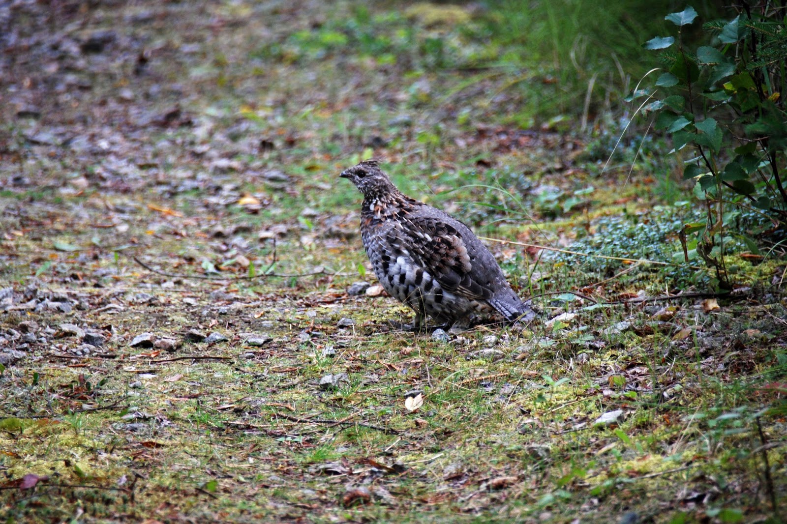 |
| Tom got a photo of a willow ptarmigan just sunning itself in one of the unoccupied campsites. |
18 Aug 2016 - Tok to Congdon
Creek Provincial Campground, YT
Yet another day of miserable
driving. Even though the repair crews had been through from Tok to the Canadian
border this summer, we probably averaged about 40 mph due to slowing for frost
heaves. We did see a bit more of the mountains in the distance to the south
than we’d seen coming into Alaska, but the intermittent rain soon started. Our
border crossing was fairly uneventful – after our experience entering Canada in
June, we decided to be truthful about the amount of wine we have on
board. Barbara told the agent that we have 21 bottles of wine (the amount in
the easily examined kneehole under the desk). About 5 vehicles were lined up behind us at the normally very
un-busy station, so the agent decided to give us a verbal lesson in the amount
of wine allowed to be brought in duty free (1.5 liters a person, or 4 bottles
total) and let us go.
From the border to Lake Creek
Territorial Campground was not too bad – intermittent rain, and a few frost
heaves, but many stretches of newly repaired/graveled road. We pulled in to
Lake Creek to have lunch, but it was early enough we decided to go on the 77
miles to Congden Creek Territorial Campground, where we had stayed on our trip
north. Tom took over the driving at 2 pm. At 5 pm we pulled into Congden Creek.
At least 40 of the miles Tom drove were active construction sites, with
washboard gravel roadbed on which we could drive about 15 mph. In one spot, we
were first in line for the pilot car but soon lost sight of it, as it was
driven so much faster than we safely could. Several RVs, towed trailers, and
pickup trucks passed us as soon as we got through that stretch of construction.
We feel like putting a sign on the back of our motorhome saying “This is our
home – we’re not going to wreck it!” We again wondered what kind of shape the
RVs that were traveling far faster than we do will be in when they get to their
destinations.
19-21 August - Congdon Creek to Whitehorse
The drive from Congdon Creek to Whitehorse was fairly scenic – we woke to sunshine and got away from the campground by 9:30. It wasn’t until we got to Whitehorse that the intermittent rain started up again, so we got a few good photos. There was little road construction, but still lots of frost heaves, so the 150 mile drive took a little over 4 hours.
 |
| The cottonwood trees (which are shrub-sized up here) have turned bright yellow, and the fireweed that had pink flowers in July have gone to seed and their leaves turned deep burgundy – very pretty. |
 |
| The mountains look quite different coming from the northwest, mostly in sun. |
We had planned to stay at the Wolf Creek Territorial campground just a few miles east of Whitehorse, but found it full when we drove through – I guess even 1:30 on a Friday afternoon shortly before school starts is too late to be finding an inexpensive, scenic camping spot! We went back to Pioneer RV Park and had no trouble getting a spot with 30 amp and water. We took our construction-filthy car to a nice wash facility in town; at $1.00 per 55 seconds, even $6 wasn’t enough to get all rid of all the grime, but it’s much better than it was. We washed the motorhome at the park’s more reasonably priced washing station on our way out on Monday.
 |
| Our spot at Pioneer RV Park |
At the Whitehorse visitor’s center, we found that Google had locked us out of our e-mail and blog services. The only way to get back in was to receive a text message on our phone with a temporary password – but since we don’t use the phone in Canada unless necessary, we didn’t have it with us.
Tom did get our Google services restarted the next day, so we were able to get a post done for this blog. We are still way behind!
This stay in Whitehorse was more leisurely than our last, since we’d hit the highlights on our first pass through.
 |
| We did drive out to the Yukon Wildlife Preserve, but they predictably don’t allow dogs on the trail through the preserve, and it was too hot(!) to leave Shelby in the car, so we just looked at the elk that were visible from the parking lot. |
We opted to go instead to the Yukon Brewing Company to taste some of their beers. We liked the Chilkoot Lager, a light, crisp brew the best. We found that they also make a scotch-style whisky and a gin. Since the whisky at $95/bottle was too rich for our budget, we thought the gin at $32 was worth a try. Haven’t tasted it yet.
We also returned to the fish ladder, but found that even though some salmon are running, they had the lower gate to the ladder closed until some hatchery staff could come and collect fish as they come up into the holding area.
 |
| Tom and Shelby resting their eyes after a day of exploring |
Our final day in Whitehorse was a stocking-up day, as we’ll be dry camping for most of the next week and a half. We returned to the Klondike Rib and Salmon restaurant, where we’d had such a good lunch on our last visit. We should have ordered the ribs. We both had the halibut dinner, which came with garlic mashed potatoes and roasted vegetables. The potatoes and veggies were very good, but the halibut was way overdone. We took our leftovers home, and the next night Barbara made halibut cakes with the fish and potatoes seasoned with dill and capers and coated with panko, with the roasted veggies on the side. A far better meal. Tom had the left over halibut cake as a sandwich for lunch, so we can’t feel too bad about getting 2 dinners and one lunch from our unsatisfactory restaurant meal.
22 - 27 Aug – Pioneer RV Park,
Whitehorse, YT to Meziadin Lake Provincial Park, BC

22 August 2016 – Whitehorse to
Teslin, YT
This drive marked the first in
a long while with sunshine, no rain, and no construction delays. We had planned
to stay at the Teslin Lake Territorial Park, but could not find a spot that was
remotely level, so continued on to the Yukon Motel and RV Park where we planned
to buy diesel the next morning. This park is typical of the north – a parking
lot with mowed weeds defining the RV spots, water and 30-amp power. It has nice
views of an arm of Teslin Lake, and a restaurant that we did not try.
23-24 August 2016 – Teslin, YT
to Baby Nugget RV Park, just west of Watson Lake, YT
The 146 mile trip took about 3
hours – almost a record. Again, we had no rain, some sun, and no construction.
One benefit of being late in the season is that much of the summer construction
is finished, and the farther along we get, the better the roads and less
frequent the work parties. It was however, a fairly boring drive with the
typical spruce and aspen forest cutting off the views most of the time.
Baby Nugget is a large park
that claims to cater to caravans, but during the 2 nights we were there, no
more than 6 or 7 of the 80 spaces were occupied. It’s the most expensive place
we’ve stayed so far, at $56.83/night (Canadian), and its services don’t rate
such a high fee. The internet (which we did not try) is available only within a
few feet of the office (no chairs or benches provided), the cable TV was so
snowy that it wasn’t worth trying to watch, they charge for showers, and they
will charge another full night’s fee if a rig stays even a few minutes after 11
am. Our main reason for staying there was to do laundry. The nice clean laundry
room had 6 washers and 6 dryers - $3 to wash and $3 to dry!
25 August 2016 – Mountain
Shadow RV Park, Cassiar Highway Mile 254.1
Another day in mostly sunshine,
no rain, and no active construction sites – we are getting spoiled. The Cassiar Highway is a
highway in name only, with no center or side lines. It is paved, but often with
the tar-gravel-sealant mixture that is like a gravel road without the loose
rock. While it is usually wide enough for vehicles to pass easily, several
sections are very narrow, with no shoulder, steep drop-offs, and many steep
curves. Low gears and exhaust brake came in handy. Only a few rough spots where
culverts had been replaced did not yet have their paving replaced, and it was
clear that long stretches of the road were resurfaced this summer. We made
fairly good time – going 196 miles in 4 ½ hours driving time.
 |
| Typical scene along the Cassiar Highway |
A number of spots
along that road had nice views of the Cassiar Mountains – even though it’s
August, deciduous trees turning yellow on the mountainsides said fall is near.
 |
| A bit of fall color along the Cassiar |
We had thought we might dry camp at the Jade City Store, a jade processing and sales operation with a large gravel lot where RVs can stay overnight. They advertise having the most reasonable prices on jade items in the north, and we hoped to pick up some Christmas gifts. Alas, their idea of reasonable prices and ours do not match, so we admired their wares and decided to travel on. After reading the mostly negative reviews of the campgrounds in Dease Lake, we decided to put in a long day to go to Mountain Shadow, which has nice long pull-through sites with 30 amp and water, with views of Kluachon Lake and a ridge of mountains with 3 dry cirques that used to hold glaciers. The half-mile
graded road from the highway to the park is quite steep and curvy (we drove it in 2nd gear), but well-graded and with no overhanging limbs.
26-27 August 2016 – Meziadin
Lake Provincial Park, Cassiar Highway Mile 96.5
We woke to rain this morning –
I guess the weather gods don’t want to spoil us too much. The drive to Meziadin
Lake was uneventful, except for a single 4-km stretch of road that was graded
and ready for the emusion top coat. Since they apparently can’t put the top coat
on in the rain, just a few minutes after we stopped to await the pilot car,
the flag lady took a call on her walkie-talkie and came back to say she was
going home. She tossed her various signs into the back of her truck, stripped
off a couple of layers of rain gear, and drove off when the pilot car arrived.
They waved us through on our own, with several cars behind us. By the time we
got through the muddy construction zone, our motorhome and car were again
coated with mud. The rest of the drive was done in intermittent drizzle and
occasional downpours, but as we approached Meziadin, the clouds broke and the
sun came out. We were able to set up without getting wet, and took a stroll
through the campground and down by the lake.
 |
| Meziadin Lake at the campground - note the fisherman wading in the shadow of the trees. |
 |
| Our spot at Meziadin Provincial Park. |
On the 27th we got
up very early (for us – 6:15 am), and drove the 40 miles or so to Stewart, BC
and Hyder, AK. Four miles past Hyder is the Fish Creek Wildlife Observation
Area, where bears are supposed to be prevalent whenever the salmon are running.
We paid our $5 each admission to the boardwalk, and yes, there were lots of
salmon and seagulls, but nary a bear. One grizzly had been seen for a few
minutes just after 6 am, but according to the ranger the bears have had so much
salmon that they are getting fat and lazy, and just eat the fish that make it
farther upstream.
 |
| Fish Creek was quite shallow, and the salmon, mostly humpbacked pinks with a few chum still around, were thrashing about trying to dig their redds, and mate. The creek was littered with fish who had spawned and died earlier. |
 |
| A mass of pink salmon moving up Fish Creek |
 |
| The view across Portland Canal at Hyder. Portland Canal is a 130-mile long fjord that forms the border between the Alaska and British Columbia at the southern end of Alaska |
The drive out to Stewart/Hyder
is beautiful, so even without seeing bears we weren’t disappointed. By the time
we drove back, the sun was mostly out, and we saw several beautiful waterfalls
cascading down from the glaciers high above.
 |
| We stopped at Bear Glacier and could hear the roar of meltwater gushing into Strohn Lake at its base. |
In the
1940s, this glacier filled the entire Bear River Canyon – today it doesn’t even
quite reach the lake, and Bear River Canyon is a mile of the creek and road
walled in by steep canyon sides.
We got back to the motorhome
about noon, and spent the afternoon enjoying the lovely warm sun and blue sky
as we read our books sitting in our comfortable Strongback folding chairs,
every now and then looking up at the forest and mountains surrounding us. Life
is good.
28 Aug - 8 Sep 2016 -Meziadin Lake to Bellingham, WA

By the time we left Meziadin Provincial Park, we were ready to be back in the States and not moving every day or so. We split the trip into 5 segments, spending 3 nights in Houston, BC at the Shady Rest RV Park, and 5 nights in Prince George, BC, then just 1 night each in the remaining 3 spots. As we got further south the weather mostly improved, with only short periods of rain.
 |
| Barbara enjoying a moment of warmth at the Kokanee Bay Motel and Campground on Lac la Hache. |
 |
| More curvy road south of Spence's Bridge, BC along the Thompson River |
 |
| Pretty turquoise Thompson River |
RV miles driven from Omak, WA to Bothell, WA: 5382
Gallons of diesel consumed: 687.6
Cost of diesel consumed: $2138
Hours of generator use: 56
Number of times we moved between 23 June and 9 September: 34
Cost of RV parks: $1795
Final observations: if we ever return to Alaska, we will fly into Anchorage and rent a motorhome for a few weeks, rather than driving the long distance to get there and back. We'd stay longer in each spot, especially in Denali, hoping to get a day when the mountain is out. We'd also like to fly back to Whitehorse and do the same - rent an RV for a few weeks' exploring, with time to wait out the weather if it's not cooperating on any given day.


